-

-
-
Loading
Loading

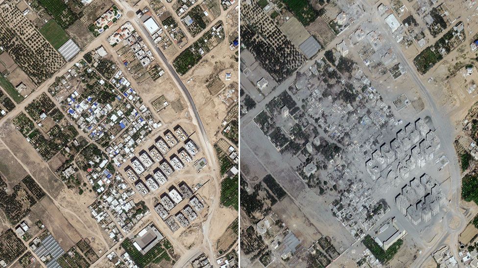
New satellite images released by Maxar Technologies reveal the extensive destruction caused by Israel's intense aerial bombardment in Gaza over the past three weeks. The pictures provide a comparison between detailed images captured from space earlier this week and images from before the recent conflict began. They highlight three areas in the northern part of Gaza where numerous tower blocks have either been completely destroyed or significantly damaged. Additionally, large sections of densely populated buildings have been reduced to piles of debris. One of the affected areas is Beit Hanoun, a settlement located just 2km (1.2 miles) away from the Israeli border in the northeastern corner of Gaza. The Israeli military claims that Beit Hanoun is a Hamas hub, and it was one of the first places where residents were warned to evacuate. The images demonstrate the dramatic transformation of Beit Hanoun, with multi-story buildings that were once standing now barely intact. The housing ministry run by Hamas estimates that roughly 45% of all housing units in Gaza have been destroyed, rendered uninhabitable, or damaged. As a result, approximately 1.4 million people have been internally displaced. While thousands of Palestinians complied with the Israeli military's evacuation orders and left their homes in the north of Gaza for their safety, some have returned despite ongoing strikes occurring in the south as well. One of the areas affected along Gaza's northern coast on the Mediterranean Sea is Al Karama, where Israeli strikes have hit areas behind the main coastal road, including hotels. In Atatra, located about 3km (1.8 miles) south of the Israeli border, more than 20 high-rise blocks and various buildings have been severely damaged. A sports facility adjacent to the tower blocks is visible in the imagery and shows its coverage in grey ash resulting from the attacks.